Showing posts with label driving in dc. Show all posts

Monday, July 4, 2011

Driving in DC #8

This one goes back all the way to my very first post on Driving in DC.  I mentioned that DC is laid out on a grid with numbered streets running north-south, and lettered streets running east-west, and stated that this was nearly a wonderful idea.  This post will explain my use of the "nearly."

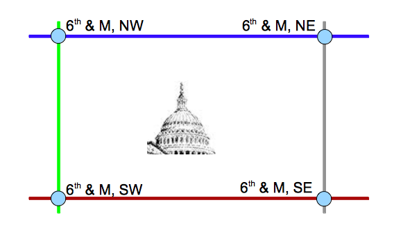
So, letters go east-west, and numbers go north-south.  Something like this:


Seems simple, right?  Kind of like Manhattan's grid system, where the avenues go north-south and the streets go east west, Washington, DC should be a similarly easy place to navigate?

Wrong.

The problem is, in Pierre L'Enfant's twisted mind, it was perfectly logical to place the origin of the coordinate system smack dab in the middle of the city: the US Capitol.  Thus, four quadrants are established.  Suddenly, instead of just an intersection, you now need a third piece of information to find the destination you're looking for.  (And, of course, the city designers were not so mathematically inclined so as to include negative numbers and negative letters in their street naming convention.)

To illustrate, let's say you're new in town, you've heard great things about the new Arena Stage, and a friend told you it's at the intersection of 6th and M.  If that's all you know, you have a 25% chance of finding the right spot on your first guess.


  • 6th and M NW is basically one block over from the Convention Center.  
  • 6th and  NE is almost the main entrance to Gallaudet University.  
  • 6th and M SE, technically, doesn't exist (6th street is blocked by the new Marine Barracks) but it's the entrance to the Chief of Naval Operation's house at the Navy Yard.
  • 6th and M SW is the Arena Stage.


This may seem trivial or minor, but when I used to live in Southwest DC, three or four times per year I would have to redirect some poor lost soul who had mistakenly wandered into the wrong quadrant.  People who live in DC or have to navigate there often learn to instinctively pick up on the "NW" or "NE" label (or just assume NW if there is no other distinguisher), but for any newcomer, beware.  It makes a BIG difference.

Thursday, March 17, 2011

Driving in DC #7

Time to go back to some regular posting for a bit: this one features the intersection of M Street and Connecticut Avenue, Northwest:


If you're new here, on this blog I sometimes try to document just how head-shakingly bad some of the areas are driving around in Washington, DC.  The topics have covered signage, absurd merge lanes, the ridiculous streets, and everything in between.  If you click on the "driving in dc" tag at the bottom of this post, you'll get all of them.

In the case of M & Connecticut, it's one of the prime examples of where the diagonal street intersections have gone laughably wrong.  It's an impenetrable morass of roads and cross traffic:


This is where M Street, Connecticut Avenue, 18th Street, and Rhode Island Avenue all converge.  I had to laugh out loud the first time I saw the traffic light in the middle of the lane.


Even with Google Maps and Street View, I can't get a good angle that accurately encompasses the acres and acres that this intersection takes up.  But you can click and scroll around to see it all.

View Larger Map

For one more grin, here's the view of the intersection as you're approaching it from Rhode Island.  I don't get it.


Lastly, here's a shot from 18th street, looking back.  The traffic flow describes this pretty well.

View Larger Map

Pictures just don't quite do this one justice.  You have to see it for yourself.

Sunday, December 19, 2010

Driving in DC #6

One of the things I have not talked about enough on this blog is the insane highway intersections common throughout DC.

Washington, DC doesn't believe in merge lanes.  They also don't believe in giving adequate warning when an existing lane is going away.  The 14th Street Bridge is a prime example of that:


I think with that picture alone, a lot of people are groaning collectively.  We've all been bitten by this, and probably more than once.

For those who may not know, the 14th street bridge is a major artery into DC:


There are only a few bridges across the Potomac into DC, and the 14th street gets you into central DC pretty quickly.  The problem is, the right-most lane of the 14th Street Bridge peels off to L'Enfant Plaza and 12th street, and hardly anybody ever takes that exit.  It may have been a nice idea during the planning stages of the city -- to have this beautiful Promenade with shops and offices and a pretty view of the Washington Channel.  But it didn't work out that way, and we're left with this enormous 2-lane exit to Nowheresville.


Neophytes to DC get nailed all the time.  In the above picture, the right-most lane forces you off the highway (with no "EXIT ONLY" warning or anything) and the second-to-right lane gives you the option of taking the exit or not.  It's way, way more capacity than that exit needs.  Or deserves.


Every morning, you can count on 1 in 3 cars making a crazy, desperate maneuver to not get unceremoniously dumped onto L'Enfant Plaza and the promenade.  And, perhaps once per week, you get a traffic-snarling accident here when someone's daring maneuver fails to account for the car in their blind spot.

Oh, the joys.

Saturday, September 11, 2010

Driving in DC #5

The Borg is coming, and this is what it looks like in Washington, DC:


Yes, that's right, it's the Department of Defense's Mark Center, located just off of Exit 4 of Interstate 395 in Alexandria, VA.  If anyone hasn't seen it yet, the building is big and imposing.  Even as it was going up as just a steel skeleton, I would think, "Holy moly, that thing is huge."  It's only 17 stories, which by New York City standards is actually pretty low, but it's designed to hold over 6,400 employees and the site itself is 16 acres -- enormous by NYC standards.

And it's the impending influx of those 6,400 employees that makes this the "Driving in DC" entry.  The nearest exit for this building is off of Seminary Road, and that already isn't pretty around rush hour.  The Army's Traffic Plan (pdf) says they plan for 3,840 parking spaces and that 20% of employees will use the shuttle buses.  Other reports say the shuttle buses will shuttle to the Mark Center from the King Street, Ballston, Franconia/Springfield, the Pentagon, and West Falls Church metro stops.

I sincerely applaud the traffic engineers' efforts to tackle this really, really difficult problem.  Obviously, military planners want a centrally-located auxiliary office building that's near the Pentagon, but not AT the Pentagon. That means inside the Beltway ... and there just aren't very many locations within the Beltway.  But, aaugh, I don't think and extra 3,800 cars coming in and out of the Seminary Road exit are going to make for a more pleasant experience on I-395 at 5pm.  And no matter how you slice it, there is some serious left-turnage involved for those coming in from the south:


(The Google Maps photo is old and doesn't reflect the new construction over the past two years.)  Add to this the other 15,000 or so workers who are being relocated to Fort Belvoir, and I-95 becomes nearly impassable.  Ouch.

I'm not the only one who's concerned.  In May, Virginia representative Jim Moran stuck language into the 2011 Defense Spending Bill that would reduce the number of parking spaces available for the new Mark Center to 1,000, unless the Army could "fully mitigate the impact on local traffic."  I'm not sure that's a productive way to go about doing things, but I'm sure it got people's attention.

As for me, I plan to watch traffic snarl on the webcam when the site opens in a year or so.

Thursday, June 10, 2010

Driving in DC #4

Often, when one is trying to navigate the twisted pile of spaghetti that is the DC roadway system, there comes a case of information overload.  The beginning of Canal Road, where it splits off from Foxhall road, is one such instance.  Glance at the picture below, as if you were driving at the posted speed limit of 35 miles per hour, and tell me if you can comprehend and process all of it:


Quick: it's 4pm on a Wednesday; should you make the turn?  If you have to think for more than about 0.4 seconds, you're too late.  You've either missed the turn, or you're now driving the wrong way down a one-way street.

I'm also standing at about the point where cars make the turn.  The print on the signs really is that small.

I completely understand the traffic designer's need to make traffic flow as smoothly as possible during the rush hours.  In this case, both lanes of Canal Road are one-way into the city (as in, opposite the way I'm facing for this picture) during the morning rush hour from 6:00 am until 10:00 am.  But then both lanes are going OUT of the city from 5pm until 7pm Monday thru Friday, except holidays.  All other times, it's two-way traffic.  On paper, or on the static desk of a traffic engineer's workspace, that probably makes sense.

But in practice, as shown in the above, there's just no way that a driver can process all that.  There are no signs preceding this one to tell you what's coming up.  There are no electronic overhead signs to tell you which lanes are valid and which ones are not.  And I bet it doesn't get any better when that orange traffic sign is uncovered. (I didn't peek to see what it says.)  Frankly, I see the giant DO NOT ENTER sign and keep on going.

The GW Parkway, on the other side of the river, is a much better way to get out of town.

Friday, February 26, 2010

Driving in DC #3

Two-way streets that turn one-way during certain times.

Take, for example, the following "average" street in Washington, DC:


Since I took this picture as a pedestrian on the corner, it's not quite the perspective you'd have as a car ... in that case, you would be about 15 feet to the right from where I took it.  But this still illustrates the point.

It's a normal intersection.  Suppose you need to make a right turn onto 15th street.  Watch out!!!  You may have missed the small writing on the following sign, which I've magnified from the above image:


From 4 to 6 pm, you CANNOT make a right turn.  It's one-way going the other way during rush hour.  This is a pretty low-visibility sign to prevent a driver from trying to swim "upstream" against the usual nasty horde of other DC drivers.  If you look at the first picture, there's a lot going on there, and the one-way indicator really doesn't stand out.

To be fair, there is also a "No Right Turn" arrow on the other side of the street with some tiny writing underneath it, but it's equally as hard to discern:


But the point of this post is not to highlight one particular poorly-marked intersection.  This street is not an oddity; there are LOTS of time-dependent one-way streets in DC, subtly marked by those black and yellow signs.

Do these exist anywhere else?  A few minutes of googling turned up nothing; they appear to be unique to the DC area.  Were I a visitor in the DC area during rush hour, the existence of these signs sure would make life difficult.

Wednesday, January 13, 2010

Driving in DC #2

K Street.


World famous for its high powered lawyers and lobbyists who plant their offices on its path, K Street sits nestled between I Street and L Street.  ("What?!?" you ask.  "The letter K is between the letters J and L, not I and L.  Where is J Street?" I smugly point out another oddity of Washington DC: there is no J Street, for reasons that are not entirely clear.  I will discuss this later.)

Between 15th Street and 20th Street Northwest, K Street espouses this utterly bizarre double-boulevard approach.  In the center is your normal, opposing-traffic road, with two lanes going in each direction.  Then comes an inexplicable island on each side, and then a "turning lane."  I use "turning lane" loosely because you don't always turn in the "turning lane."

The bicyclist in the above picture is crossing the "turning lane."  To the left of him is the normal two-way traffic, to the left of that is another boulevard, and then off to the far left is the opposing traffic's "turning lane."

There are three critical flaws for drivers who attempt to use this section of K Street:

Turning Right
Suppose you are driving down the middle lanes of K street, looking to turn right onto 17th street.  When you arrive at 17th street, you are not allowed to turn right from the center lanes onto 17th street.  No, instead, you had to have anticipated your turn onto 17th street from 15th or 16th street, and merge from the center lanes into the turn lane.

But it's not always a simple merge, because some traffic is already in the "turn lane" but wants to go straight.  You have to fight and claw your way into this stream early if you want to turn, and nobody is willing to yield the right-of-way.  This is why you're not allowed to turn right from the center lanes -- you would be cutting off that traffic that is trying to go straight through the intersection from the "turn lanes."

Turning Left
Many of the intersections between 15th and 20th do not allow left hand turns, but a few do.  On those that do, the left turners must not only artfully dodge the immediate two lanes of opposing traffic, but must also navigate the opposing "turning lane" traffic.  This is especially difficult because, in a string of cars, it's impossible to see which ones have their right-turn blinkers on and which ones don't.  You have no idea what the intentions are of the opposing "turning lane" traffic, and half the time it's a guess and you hope the opposing traffic doesn't mash the gas pedal just to ram into you.

Turning onto K Street
If you're coming from any of the side streets, and you turn right onto K Street, you're only allowed to turn into the "turning lane."  At the next intersection (a block or two further down), you are supposed to merge into the center lanes to get with the flow of traffic.  But be careful!  Some of the traffic is trying to merge from the center lane into your "turning lane."  Heaven help you if it's a cab and you're in his way.

Summary
I see many disadvantages to this system, and few advantages.  It is a very cruel and disorienting arrangement, particularly to drivers unfamiliar with K Street.  It's also the only street in DC that I know of to be set up this way.  It certainly wastes a lot of space; I would rather see an extra full-traffic lane or two carved out for K Street (it gets very busy and congested during rush hour), and maybe even room for a wider sidewalk.

Fortunately, I'm a pedestrian most days on K Street, so I don't have to deal with these intricacies.  But the multiple lanes of traffic sure make me feel like Frogger some days.

Post Script
I said I would talk about the absence of "J Street."  The urban legend -- and one that I subscribed to for many years -- was that Pierre L'Enfant, along with most of the rest of the country, was incensed at John Jay for signing the Treaty of Amity, Commerce, and Navigation with Great Britain, that was far too kind to Great Britain and the fledgling US got nothing in return.  For punishment, Pierre removed "J Street" from the DC street grid.

However, the venerable snopes.com has a different explanation: that the letters "I" and "J" were too hard to distinguish, so J was omitted.  This makes more sense than the urban legend, since Pierre was removed from his job in 1792, and the treaty wasn't signed until 1794.  This is also stated as the reason by both Wikipedia and a former DC tour guide, although it's possible that all 3 are quoting the same source.

Tuesday, January 12, 2010

Driving in DC #1

This is the first of a long series of posts about the joys of driving in and around Washington, DC.


Yes, that's right.  This is an actual sign marking the intersection of Virginia Lane and ... Virginia Lane.  It is a four-way intersection, although there is no stop sign to really mark it.  Kudos to the street planners who come up with creative names for different streets.

Driving in DC

Driving in Washington, DC, is an interesting experience.  In this context, "interesting" can be further refined as any of the following:
  • Terrifying
  • Confusing
  • Hopeless
  • Chaotic
  • Efficient
Often, driving in DC is about as effective at getting you from Point A to Point B as Brownian Motion.  Notice, however, that I left "efficient" as the last bullet.  To be fair, in about 5% of cases, the driver says, "Holy crap, there's [insert road] that will take me directly to where I want to go!"  Sadly, in the other 95% of cases, some serious intestinal fortitude and luck are required to get you to where you want to go.  Observe.


DC starts out with a grid pattern: numbered streets (7th, 9th, 23rd, etc) running North-South, and lettered streets (K Street, M Street, etc) running East-West.  This is a nearly wonderful idea. (The "nearly" will be explored in a later post.)  It works well for Manhattan:


In the grid pattern, if you know where you are, it's pretty simple to figure out how to get where you want to go.  (I admit to biasing this to mid-town Manhattan.  Lower Manhattan is not as orderly, but I'm willing to cut them some slack due to geographical constraints.  The island narrows down there, and it's harder to maintain a grid.)

But then Pierre L'Enfant played what is perhaps the greatest practical joke of all time: completely obfuscating another nation's Capital city and making it utterly bewildering to visitors.  He took what was said to be a "clean slate" and overlaid a haphazard arrangement of diagonal streets on top of the grid.  These are the states: Pennsylvania, Massachusettes, New York.

Taken by themselves, the diagonals aren't so bad.  But where the diagonals intersect with the grid is where it all falls apart, and you have an inscrutable network of acute and oblique angles of intersections.  And where two diagonals meet, on top of the grid, only Dante can describe it: Abandon all hope, Ye who enter here.

That's right, Dupont Circle.  I'm lookin' at you.  You will be featured prominently in these pages.

In a final touch of class, our dear Frenchman inserted a few final obstacles: parks, squares, and the maelstrom known as the Rock Creek Parkway.  Some of these are quaint -- and they go a long ways towards making the city more friendly -- but their haphazard locations, sizes, and shapes make me genuinely discombobulated as I'm trying to drive around.

A walking city?  Perhaps.  But a driving city?  Fuhgeddaboudit.

I have lived in DC for 10 years, and the Rock Creek Parkway still scares me.  There are those who claim to have mastered the RCP, and they claim to value its utility.  I don't believe them.  My general rule is:

If you don't know exactly how to get from A to B, don't even start until checking the map.  You WILL NOT be able to figure it out on the way.

The RCP is never, ever, ever in the set {A, B} for any A or B.

---------

Anyhow, enough mindless ranting.  No assertion is worth much unless it can be documented and demonstrated.  So that's what the purpose of this series is: documenting examples of the crazy, intimidating, and obtuse "sport" that is known as Driving in DC.  If you have examples of your own, shoot me an email or leave them in the comments.